
Brief description
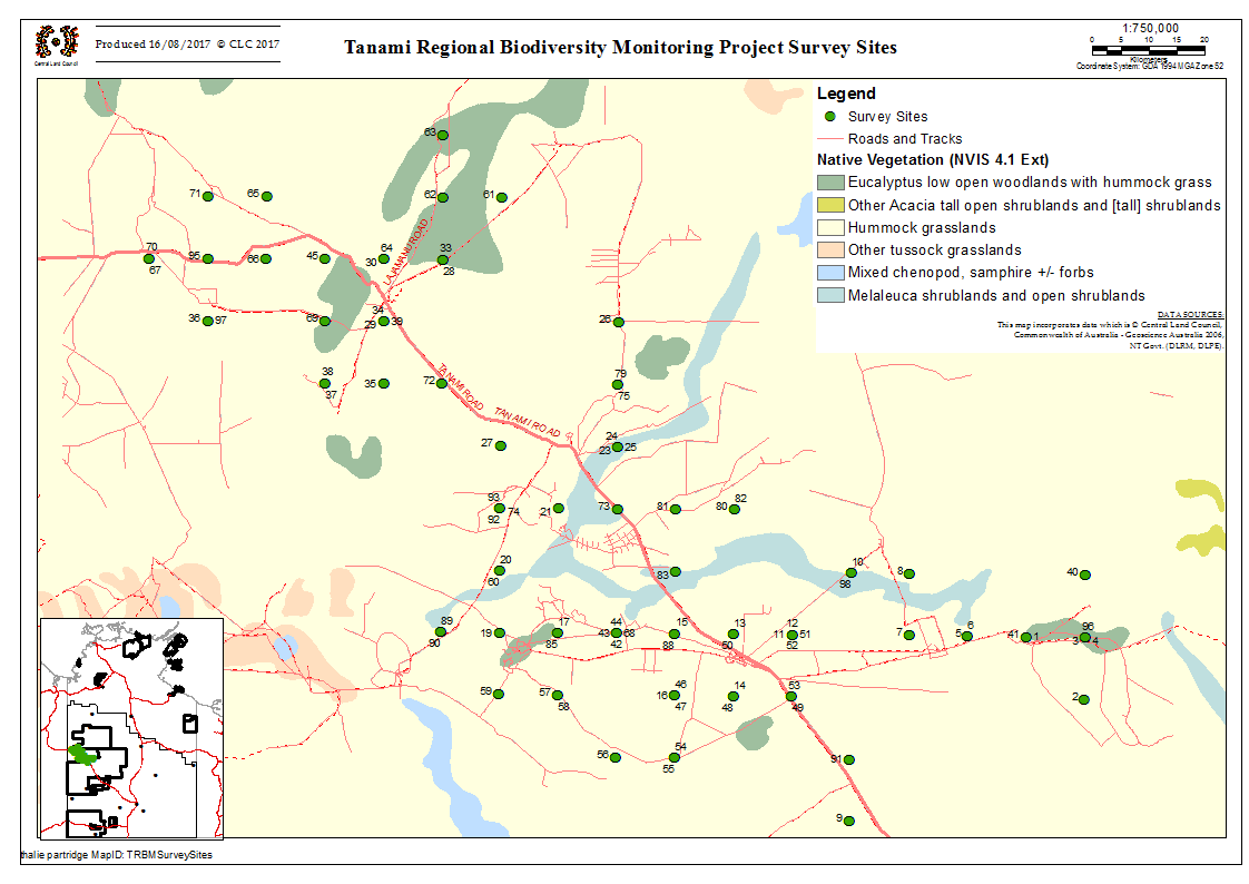
The dataset contains biological data collected 2005, 2012 as part of the Tanami Regional Biodiversity Monitoring (Tanami RBM) program. The Tanami RBM program uses 89 sites across the Tanami region, central-west Northern Territory. At these sites, flora and fauna are surveyed during the late-dry (usually November-December) or late-wet (usually February-March) seasons. Each site comprises a 200 m x 300 m survey plot from which the data are recorded using various survey methods: site descriptions, vegetation transects, bird surveys, small vertebrate trapping, and tracking surveys. This dataset contains the data from eight surveys undertaken between 2005 and 2012: six in the late-dry and two in the late-wet seasons. The precision of site locations has been reduced to 0.1 decimal degree, which is approximately 10 km at the study region. This denaturing is because some sites contain threatened and/or sensitive species that might be at risk from collection or disturbance. The dataset contains species information from vegetation surveys and fauna species captures and observations. The data can be used to: [1] Review the outcomes of the survey methodologies [2] Presence data of the species recorded [3] Impacts of mining on the region's flora and fauna e.g. what is the spatial and temporal impact of mining activities on biota? [4] Conservation and biodiversity e.g. what are the spatial and temporal trends in the occurrence of key/threatened species? How do land units/systems change over time?Lineage
Collection method:[1] Site selection and description method: All methods sections are described in a single document Tanami RBM methods available within the supplementary materials. Ninety-eight sites were initially selected for the Tanami Regional Biodiversity Monitoring (Tanami RBM) program. Sites were stratified across (i) land unit, (ii) north-south region, and (iii) proximity to mining areas. Approximately 10 sites were used in previous monitoring in relation to the rehabilitation of mine waste dumps at Dead Bullock Soak, Tanami Mine, Dogbolter and Redback Mines (Low et al. 1998, Low et al. 2003, Foster & Low 2004). Sample independence was attained by locating sites at least 4 km apart. The total sample size was deemed statistically robust, but the final number of sites (total and for each sampling technique) was also determined by logistical and financial constraints (Foster & Low 2004). (i) Land units: Land units, used as surrogates of biodiversity, were derived by combining the characteristics of regolith units (Wilford & Butrovski 1999). Regoliths with similar geology, soils and landform were grouped into inferred similar land units, forming ten land units over the study area. Existing biological data showed the greatest species diversity occurred in six of the ten mapped land units. Ranked by greatest species diversity, these were: 1) loamy sandplain, 2) palaeodrainage, 3) lateritic sandplain, 4) lateritic rise, 5) elevated drainage depression, and 6) chert rise. During the on-ground site establishment phase in December 2004, lateritic and chert rises were found to be a graded ecotone rather than discrete units. Therefore, laterite and chert rises were subsequently combined into a broader rocky rise land unit. Lakes, separate from paleochannels, were also added to the final list of six land units across which the 98 sites were stratified: 1) loamy sandplain, 2) palaeodrainage, 3) lateritic sandplain, 4) rocky rise (lateritic and chert), 5) lake (fresh and salt), and 6) elevated drainage depression (ii) North-south sub-region: Sites were stratified across a northern group and a southern group, divided at approximately 20° 15 S latitude (8 km south of Rabbit Flat Roadhouse). The purpose of the division was to test theories of declining biodiversity across a north to south gradient of increasing aridity. (iii) Proximity to mining area: A threshold of 15 km from a mining area was selected as the basis for investigating the impact of mining activities on local biota. As dingoes use mine sites for water and food, smaller fauna near mine sites are at risk from predators drawn to the mine. Sites less than 15 km from a mine were designated as impact sites and those greater than 15 km were designated as control sites. (iv) Site establishment, description and sampling protocol: Due to logistics and access constraints, eighty-nine sites were used in the final monitoring program. Survey plots of 300 m x 200 m were installed at each of the 89 sites, following the protocol described in Neave et al. (2004), and marked permanently with steel droppers on diagonally opposite corners (Figure 1: see supplementary methods). The dominant features of each site, including substrate and disturbance levels, and dominant plant species, were recorded during the first survey (Late wet season 2005) from a 50 m x 50 m quadrat centred at the survey plot (TRBM_site_description.csv: supplementary materials). Incidental fauna sightings were also recorded at each site or on route to sites. The land unit and target species defined the appropriate sampling methods that were used at each site (Table 1: see supplementary methods), a combination of bird surveys, tracking, small vertebrate trapping, tree health, and vegetation transects. Note, tree health data are not available in this dataset. The 89 sites were surveyed, with their respective sampling method, on eight occasions in the late-wet season (LWS, February-April: 2005, 2006) and late-dry season (LDS, November-December 2005, 2006, 2007, 2008, 2009, 2012). The precision of site locations has been reduced to 0.1 decimal degree, which is approximately 10 km at the study region. This is because some sites contain threatened and/or sensitive species that might be at risk from collection or disturbance. References: Foster, E. & Low, W.A. (2004). A Framework for Regional Monitoring of Selected Wildlife in the Tanami. Report to Newmont Tanami Pty Ltd., Alice Springs, N.T. Low, W., Miller, C. and Johnson, C. (1998) Landscape, Flora and Vertebrate Fauna Survey of the Proposed Mineral Leases at Tardis and Molech. Report to Otter Gold NL., Darwin, N.T. Low, W., Cassanet, M. and Hill, A. (2003) Environmental Impact Assessment of Minotaur ML(A) 23283 and Windy Hill Haul Road, December- January 2002/03. Report to Newmont NFM Tanami Operations, Alice Springs, N.T. Neave, H., Nano, C., Pavey, C., Moyses, M., Clifford, B., Cole, J., Harris, M. and Albrecht, D. (2004) A Resource Assessment Towards a Conservation Strategy for the Finke Bioregion, NT. Draft unpublished final report to the Commonwealth Department of the Environment and Heritage, NHT Project No. 990006. Conservation and Natural Resources, Department of Infrastructure, Planning and Environment, Alice Springs, N.T. Wilford, J.R and Butrovski. D (1999). Tanami Granites Regolith-Landforms Map Series; (1:100,000 map scale). Unpublished report to Newmont NFM Tanami Operations, Alice Springs, N.T.[2] Vegetation transect method: Vegetation was recorded at 85 of the 89 monitoring sites. Plant species and corresponding height classes were recorded at 1 m intervals along a 300 m transect in each survey plot (Figure 1: see supplementary methods). Transects were completed by one or two teams of two people, using a 50 m measuring tape. Voucher specimens of unknown species were collected for subsequent identification. At each 1-m point along the transect, each plant species and its corresponding height class was recorded (1: 110 cm, 2: 10-25 cm, 3: 25 50 cm, 4: 50-100 cm, 5: 100-200 cm, or > 200 cm). If multiple plants occurred at one location, the species and height class was recorded for each stratum (GroundLayer and Height-g, UpperLayer1 and Height-u1, UpperLaye2 and Height-u2, UpperLayer3 and Height-u3). Plant voucher specimens were identified by the Alice Springs herbarium.
[3] Bird survey method: Bird taxa were recorded at 31 of the 89 monitoring sites. All birds seen or heard from the survey plot were recorded over a 15-minute period each morning and evening by a dedicated observer. Bird species, and the number of individuals seen or heard, were recorded for three mornings and three evenings each survey. During survey years where lakes or paleochannel sites (n=6) were inundated, a wetland bird census was undertaken for 15 minutes.
[4]: Small vertebrate trapping method: Trapping for small vertebrates was undertaken at 31 of the 89 monitoring sites. Two trap types were used: (i) pit traps and (ii) Elliott traps. (i) Pit traps: Four pit traps were permanently established at each survey plot (Figure 1: see supplementary methods). Each pit trap was a PVC bucket (0.3 m diameter x 0.4 m deep). Each bucket was sunk vertically into the ground so that the top rim was at ground level. A mesh fence (0.3 m high x 10 m long) was erected across the pit, 5 m each side of the bucket, and secured by metal pins and a shallow trench. Pit traps were open for three days and three nights each survey. Pits were checked during the early morning and mid-afternoon to reduce heat stress and ant attack of trapped animals. (ii) Elliott traps: Twenty-five Elliott traps were positioned at 10 m intervals along a 250 m transect at each survey plot (Figure 1: see supplementary methods). Elliott traps were open for three nights during each survey. All 25 Elliott traps were set in the late afternoon, using a 1.5 cm ball of bait in each trap, and checked in the morning before 10:00 hrs. Traps were then closed and left in place until re-opening in the late afternoon. Data collection: The snout-vent length (SVL) and total length (TL) of captured vertebrates were recorded in all cases except when the animal escaped or when large numbers of one species was captured (e.g. Lerista bipes). The hindfoot length of mice were recorded as an aid to identification and estimating age class, but are not included in this dataset. Records of captured animals were grouped by site. Animals were not marked between trapping sessions, therefore re-captured animals may have been recorded more than once in the same survey year.
[5] Small vertebrate trapping method: Trapping for small vertebrates was undertaken at 31 of the 89 monitoring sites. Two trap types were used: (i) pit traps and (ii) Elliott traps. (i) Pit traps: Four pit traps were permanently established at each survey plot (Figure 1: see supplementary methods). Each pit trap was a PVC bucket (0.3 m diameter x 0.4 m deep). Each bucket was sunk vertically into the ground so that the top rim was at ground level. A mesh fence (0.3 m high x 10 m long) was erected across the pit, 5 m each side of the bucket, and secured by metal pins and a shallow trench. Pit traps were open for three days and three nights each survey. Pits were checked during the early morning and mid-afternoon to reduce heat stress and ant attack of trapped animals. (ii) Elliott traps: Twenty-five Elliott traps were positioned at 10 m intervals along a 250 m transect at each survey plot (Figure 1: see supplementary methods). Elliott traps were open for three nights during each survey. All 25 Elliott traps were set in the late afternoon, using a 1.5 cm ball of bait in each trap, and checked in the morning before 10:00 hrs. Traps were then closed and left in place until re-opening in the late afternoon. Data collection: The snout-vent length (SVL) and total length (TL) of captured vertebrates were recorded in all cases except when the animal escaped or when large numbers of one species was captured (e.g. Lerista bipes). The hindfoot length of mice were recorded as an aid to identification and estimating age class, but are not included in this dataset. Records of captured animals were grouped by site. Animals were not marked between trapping sessions, therefore re-captured animals may have been recorded more than once in the same survey year.
[6] Trackplot method,Tracking method: Tracking was undertaken at 85 of the 89 monitoring sites. A 300 X 200m trackplot was searched for a period of one-person hour, typically four people for 15 minutes. Trackplots were sampled before systematic fauna sampling to avoid disturbing the soil surface. Trackplots were given a trackability score or a comment on the tracking substrate. Animal sign was recorded (tracks, burrows/nests, scats, diggings and remains) and identified to species where possible. The age of the animal sign was estimated and would depend on the clarity of the print, the weather conditions and known behaviour of species present. Home activity was recorded as either active, inactive or abandoned. References: Masters, P., Nano, T., Southgate, R., Allan, G. and Reid, J. (1997) The Mulgara: Its Distribution in Relation to Landscape Type, Fire Age, Predators and Geology in the Tanami Desert. Parks and Wildlife Commission of the Northern territory, Alice Springs, N.T.
Notes
CreditWe at TERN acknowledge the Traditional Owners and Custodians throughout Australia, New Zealand and all nations. We honour their profound connections to land, water, biodiversity and culture and pay our respects to their Elders past, present and emerging.
The project was developed and implemented through a collaboration between Central Land Council (CLC), Low Ecological Services (LES) and Newmont Tanami Operations (NTO). Traditional owners for the region played a prominent role in the project. This included approval of access to sites, logistical guidance, data collection, and cyber tracker data entry. The traditional owners recognised and supported the importance and value of this scientific research and wished to see increasing involvement of Yapa (Warlpiri people) in this sort of work as well as recognition of Indigenous knowledge within the region by the wider scientific and Australian community. The South Tanami IPA management committee provided advice on sensitive data management and data sharing. Metadata development and data quality and validation for this dataset was undertaken by Thalie Partridge (CLC) and Claire Treilibs (LES) with assistance from Bill Low (LES). Newmont Tanami Operations provided significant funding and logistical support for both the field surveys and preparation of the dataset for online publication. Additional support for field surveys was provided by Tanami Gold, ABM Resources, Northern Minerals, and ERO mining. CLC Warlpiri Rangers and North Tanami Rangers and other CLC staff undertook significant fieldwork to survey fauna and flora. Fieldwork, equipment and logistics was funded through the Australian Government, Working on Country program, the North and South Tanami Indigenous Protected Areas, and Newmont Tanami Operations. Database support and maintenance was funded through the Aboriginal Benefits Account, the Indigenous Protected Areas program and Newmont Tanami Operations. CLC and LES staff managed logistics and stakeholder coordination. Low Ecological Services coordinated collection of biodiversity data, transcribed the data, and compiled summaries of each survey, as well as an early statistical review of the project by T. Newsome, R. Cunningham and C. Donnelly (2009). These unpublished reports can be made available on request through CLC.
Newmont Tanami Pty Ltd (Newmont), in conjunction with the Central Land Council (CLC) in 2004 established the Tanami Regional Biodiversity Monitoring (Tanami RBM) program for the central and northern Tanami, Northern Territory. The program's framework was developed in consultation with a diverse range of stakeholders, and with the primary aim of assessing the impacts of current or proposed mining activity on the region's biota. Original objectives of the program were to: [1] Establish a biological and landscape information base from which to assess the impact of current and/or proposed mining activity, which will also assist in the future planning of Indigenous and industrial land management of the Tanami desert; [2] Monitor the distribution and abundance of selected wildlife within the vicinity of mining activity in the central and northern Tanami; [3] Enhance training, employment and enterprise development opportunities for traditional Aboriginal landowners within the Tanami region's indigenous communities. This dataset supports objectives 1 and 2.
Created: 2005-02-26
Issued: 2018-06-06
Modified: 2026-07-07
Data time period: 2005-02-26 to 2012-12-03
text: The survey sites are located in the Tanami Desert, within the Central Desert, Mount Frederick and Mangkururrpa Aboriginal Land Trusts. More than half of the sites occur within the Southern Tanami and Northern Tanami Indigenous Protected Areas. An Indigenous Protected Area (IPA) is an area of land cared for by the traditional owners (in the study area, primarily Warlpiri people, though other Indigenous people may maintain connection with this area). The aim of an IPA is to protect biodiversity and conserve the area's cultural resources. An IPA is recognised under the Australian National Reserve System and the International Union for Conservation of Nature (IUCN) Categories 5 and 6, which support conservation and other sustainable uses to deliver social, cultural and economic benefits for local Indigenous communities. Central Land Council is a representative body which supports Aboriginal people to manage their land through the Aboriginal Land Rights Act 1976. The nearest communities to the study area in the Northern Territory are Yuendumu and Lajamanu and in Western Australia, Balgo and Billiluna.
User Contributed Tags
Login to tag this record with meaningful keywords to make it easier to discover
- URI : geonetwork.tern.org.au/geonetwork/srv/eng/catalog.search#/metadata/2431b4be-a23d-4e7e-b5cc-ff7fee0ecc6f

- global : 2431b4be-a23d-4e7e-b5cc-ff7fee0ecc6f
