
Full description
The objective of this software is to enable hind-cast modelling of monthly Gross Primary Production (GPP) for the Australian continent- using a variety of input data sources.
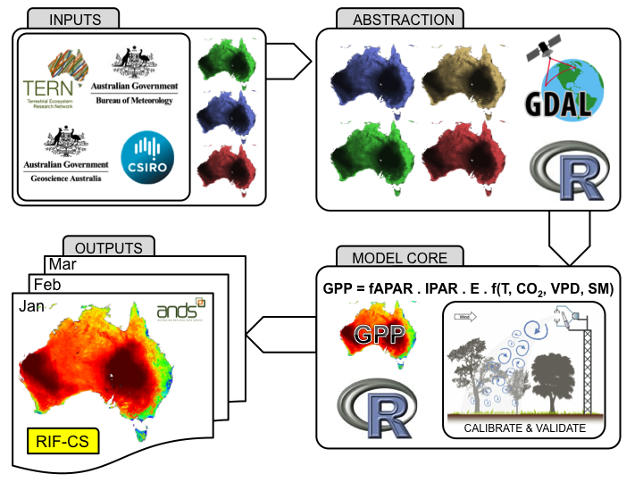
The software consists of two main parts (refer Figure 1);
1. A data abstraction layer, containing tools for formatting model inputs neccesary to model GPP.
2. A model core containing tools for calibration and validation of the model against Australian flux tower observations and ultimately, gridded monthly hind-casts of GPP.
The software was designed “by the community for the community”, meaning it is intended to be used for generating new “simple models” using the authors own model as the benchmark. This purposely-inbuilt transparency makes it a sustainable platform for future generations of GPP models of this kind. As such, the software package has the following general features;
a. It is capable of reading and re-gridding a range of datasets from the Terrestrial Ecosystem Researcg Network, Australian Government Bureau of Meteorology and Geoscience Australia. This software layer is called- The Data Abstraction Layer (TDAL).
b. It features a modular design, making it usable as a stand-alone tool OR embedded inside another workflow OR ported to a completely novel model core.
c. It facilitates point-to-point calibration and validation against OzFlux tower data across a range of spatial and temporal scales.
d. It has been written in an open source language with the intention of ongoing, cross platform interoperability.
The software has been written as an R-Project package. R is widely used for benchmarking within our user community, one example of this is PALS. Data abstraction was implemented using the Geospatial Data Abstraction Library (GDAL), more specifically, RGDAL bindings and the raster package are used for low-level reading and writing of data and to facilitate the high-level model functions required for the model and modelling system functionality.
Delivery method
Software
User Contributed Tags
Login to tag this record with meaningful keywords to make it easier to discover