
Brief description
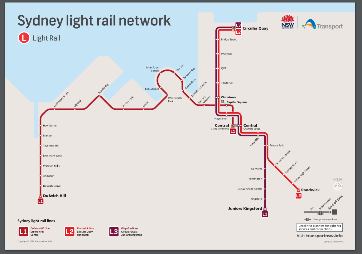
The Sydney light rail network is a light rail system serving the Australian city of Sydney. The network currently consists of three passenger routes, the L1 Dulwich Hill (currently suspended), L2 Randwick and L3 Kingsford lines.\n\n\nThis dataset provides WCAG 2.0 compliant wayfinding maps for 42 Sydney light rail stops. Each map displays the local area map and the stop map providing information such as transport connections, customer assistance and tickets.\n\n\n**Current Sydney light rail network** \n\n! sydney light rail network map \n\n\nFull description
L1 Stop GuidesArlington stop guide
Bridge Street stop guide
Capitol Square stop guide
Central Chalmers Street stop guide
Central Grand Concourse stop guide
Chinatown Stop guide
Circular Quay stop guide
Convention Stop Guide
Dulwich Hill Stop Guide
Dulwich Grove Stop Guide
ES Marks Stop guide
Exhibition Centre Stop Guide
Fish Market Stop Guide
Glebe Stop Guide
Hawthorne Stop Guide
Haymarket Stop guide
John Street Square Stop Guide
Jubilee Park Stop Guide
Juniors Kingsford Stop guide
Kensington Stop guide
Kingsford Stop guide
Leichhardt North Stop Guide
Lilyfield Stop Guide
Lewisham Stop Guide
Marion Stop Guide
Moore Park Stop guide
Paddy's Markets Stop Guide
Pyrmont Bay Stop Guide
QVB stop guide
Randwick Stop guide
Royal Randwick Stop guide
Rozelle Bay Stop Guide
Surry Hills Stop guide
Taverners Hill Stop Guide
The Star Stop Guide
Town Hall stop guide
UNSW Anzac Pde Stop guide
UNSW High St Stop guide
Waratah Mills Stop Guide
Wentworth Park Stop Guide
Wansey Rd Stop guide
Wynyard stop guide
Royal Randwick stop guide (Effective to 4 Dec 2021)
ES Marks stop guide (Effective to 4 Dec 2021)
Chinatown stop guide (Effective to 4 Dec 2021)
Juniors Kingsford stop guide (Effective to 4 Dec 2021)
Moore Park stop guide (Effective to 4 Dec 2021)
Randwick stop guide (Effective to 4 Dec 2021)
Haymarket stop guide
Kingsford stop guide (Effective to 4 Dec 2021)
Surry Hills stop guide (Effective to 4 Dec 2021)
Kensington stop guide (Effective to 4 December 2021)
UNSW Anzac Parade stop guide (Effective to 4 Dec 2021)
UNSW High Street stop guide (Effective to 4 Dec 2021)
Wansey Road stop guide (Effective to 4 December 2021)
Arlington stop guide (effective to Nov 2021)
Capitol Square stop guide (effective to Nov 2021)
Central Grand Concourse stop guide (effective to Nov 2021)
Convention stop guide (effective to Nov 2021)
Dulwich Grove stop guide (effective to Nov 2021)
Dulwich Hill stop guide (effective to Nov 2021)
Exhibition Centre stop guide (effective to Nov 2021)
Fish Market stop guide (effective to 2021)
Glebe stop guide (effective to Nov 2021)
Hawthorne stop guide (effective to Nov 2021)
John Street Square stop guide (effective to Nov 2021)
Jubilee Park stop guide (effective to Nov 2021)
Leichhardt North stop guide (effective to Nov 2021)
Lilyfield stop guide (effective to Nov 2021)
Lewisham West stop guide (effective to Nov 2021)
Marion stop guide (effective to Nov 2021)
Paddy's Markets stop guide (effective to Nov 2021)
Pyrmont Bay stop guide (effective to Nov 2021)
Rozelle Bay stop guide (effective to Nov 2021)
The Star stop guide (effective to Nov 2021)
Taverners Hill stop guide (effective to Nov 2021)
Waratah Mills stop guide
Wentworth Park stop guide (effective to Nov 2021)
Identifiers
- URI : data.nsw.gov.au/data/dataset/2-sydney-light-rail-stop-guides

- Local : f62d02e3-ea1f-4b01-ab3f-9da3dd8f499b
